North Fork Coeur d'Alene: Big Hank to Shoshone Camp
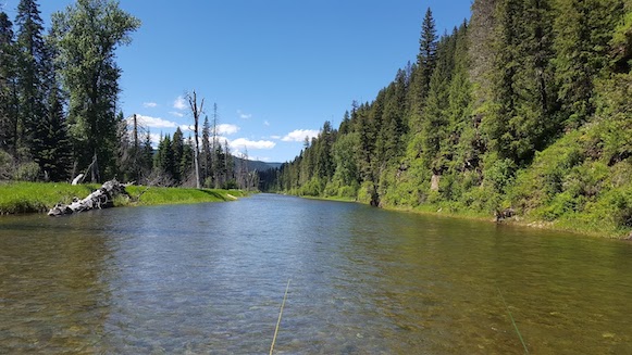
North Fork at 900 cfs at Shoshone Creek: Photo copyright Todd Hoffman 2022
Fishing:
Fishing on the North Fork is catch and release only, and requires single, barbless hooks and artificial lures or flies. In recent years the fishery has suffered from warming water temps, and it also sees heavy fishing pressure (including from people that don't follow catch and release and equipment regulations). If you're looking for a world class fishery, the North Fork is not it, though it does still have some opportunities. Be ready for challenging conditions if you come here to fish. Also, flows that are at runnable for rafts and drift boats on this section are generally too high and too early for optimal fishing conditions.
Run Description:
Big Hank is the upper-most, roadside section of the North Fork. Fortunately, there are
many long, isolated back stretches of river, well away from the road, giving it a
very wild feel. The scenery in this part of the river corridor is outstanding, which makes the
run worth doing, despite the lack of whitewater and even though it doesn't have the best
fishing.
While there are no rapids to speak of on the run, wood can be a hazard and its not really
possible to road scout the entire reach. At higher flows the water is moving faster than it
looks from the road, and in the early season the temps can be cold and the mountain weather can
change rapidly. Dress appropriately and wear your PFD. It's also a fairly long float so
bring drinks and snacks.
Unfortunately, most of the lower reaches of the North Fork have become seriously over-crowded,
and it is not uncommon to find trash and even grafitti at popular locations (in other words
everywhere). This last wild section of the Coeur d'Alene could use some appreciation from
responsible users that want to take care of it. Please do your best to be a good steward.
Logistics:
The put in is located on river left just below Big Hank Forest Service campground in Big
Hank Meadows. Just before Big Hank Campground the road crosses over the river. Look for
a primitive access road just past the bridge on the East side of the road. Four wheel drive
or high clearance is recommended as the access road fords a fairly deep creek before entering
the meadow. There is good boat trailer access right to the water's edge, and plenty of
room to turn around and park.
The take out is located just past Shoshone Creek on the West side of the road. Look for a
turn out / parking area just past Shoshone Creek Ranch, an old Forest Service facility that now
serves as a youth summer camp operated by Lutherhaven Ministries. From the parking area,
there is a primitive road leading to river's edge. While it can be tricky to back down, it
is possible to get a trailer all the way to the water here. The USGS gauge is also located here.

Boat Ramp at Shoshone Creek take out: Photo copyright Todd Hoffman 2025
If you're coming from the West (Coeur d'Alene or Spokane) best access is from Kingston,
Idaho on Forest Route 9, aka Coeur d'Alene River Road. Take the Kingston exit on I-90 and head North.
If travelling from the East (Missoula or Wallace), best access is from the town of Wallace
over Dobson pass. It's 17 miles from Wallace to the North Fork. Head up Nine Mile Creek
from Wallace and continue over the pass till your hit the river, then head upstream.
As of June 2022, shuttles are available from Castaway Fly shop in Enaville, just a short
distance up the road from Kingston (on the right just past the Snake Pit Restaurant and Bar).
They prefer that you stop in the morning of your trip to book instead of calling ahead.
Its best to get there early to make sure your get on their schedule before their shuttle
drivers start for the day. The shuttle drivers ask that you park your vehicle just off
the main road so they can avoid fording the creek to get it (they drive a Prius).
Flow Information:
I have rafted this section at 1,100 cfs and at 950 cfs on the Shoshone Creek gauge. Both flows had more than sufficient coverage, and made for a nice pace on the river, taking 4+ hours to complete the run. You could probably get a raft or drift boat down it as low as 500, but it would be a painfully slow run, with the possibility of scraping out in a few places. Flows in the 1,000 cfs range were too high for good fishing. In most years the run has an early season, probably finishing by the first week of June. In good snow years it can run into July.

North Fork running 1,600 cfs at Shoshone Creek in mid April: Photo copyright Todd Hoffman 2025
Stream Stats:
| Ave Gradient: | ~20 fpm |
| Distance: | ~12 Miles |
| Difficulty: | II+ |
| Consequences: | III |
| Min Level: | ~500 CFS |
| Season: | May - June |