Canyon Creek: Yellow Dog to Wallace Visitor Center

Scouting Yellow Dog Rapid on Canyon Creek @ 250 cfs.
Run Description:
Canyon Creek, located in historic Burke Canyon, is one of the most abused rivers in North Idaho. It's entire streambed has been heavily modified, and is full of sharp blast rock, concrete ruins, wood and other hazardous debris. Up until the late 1990's raw sewage was piped straight into the creek from the houses in the canyon, giving it's local nick name - Shit Creek. There is also significant contamination from historic mine tailings through out the watershed, and the creek and surrounding area are part of an EPA Superfund clean up site. Somewhere around 2007, a project was undertaken to stabilize Canyon Creek's streambed. Several large rock structures were built to reduce erosion, and woody debris was added to help provide acquatic habitat. Its making a slow transformation back to a healthy stream, but it has a long way to go.
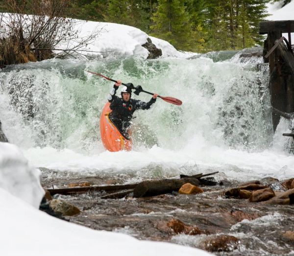
Chris Mowry running Tetanus Falls - Photo Copyright Chris Celentano.
The run is informally split into upper and lower sections. The lower runs from the assay lab (located around 3.7 miles up Burke Canyon), to the confluence with the South Fork, then down the South Fork to the Wallace visitor's center. The upper section starts near the ruins of the Star Mine. The top section is steeper, more channelized and is quite a bit more challenging. The lower section generally requires more water to get down as it flows through an open part of the canyon where the creek starts to meander. The put in for the upper is at the ruins of an old diversion dam (Tetanus Falls), located between the townsites of Cornwall and Mace, just below the Star Mine. The dam is is located on the river left side of the canyon in a wide turn out area, just after a bridge. it is not visible from the road. The dam has been run on the river right side at flows above 350. With less water it could have a shallow landing so be careful.
Canyon Creek
Hazards of special concern are low bridges, tunnels, concrete ruins and shifting wood. On the upper part of the run, the creek passes under a couple of bridges that should be carefully checked for wood on the drive up. Lower down, just at the confluence with the South Fork, the run passes through a small tunnel. Immedately down stream from confluence is another very long tunnel where the South Fork passes under one of the streets of Wallace. Scout all these places carefully for new wood or debris before your run. There have been a few close calls Canyon Creek. Be extremely careful.
Flow Information:
There is an online gauge for Canyon Creek located near the confluence with the South Fork. Look for around 350 cfs to run the upper, and a hair more for the lower, though it is possible to run both sections on the low side of 300. Note that if flows on the South Fork At Wallace gauge are above 1,200 CFS, the level may be too high to float under the bridge near the Wallace library. Be sure to check it if you plan on floating all the way out the South Fork.
Logistics:
The most common take out is at the Wallace Visitors center.
Take the first Wallace exit as you enter town from the West and you can't miss it.
It has clean restrooms for changing and plenty of parking. It is possible to extend
the run by taking out a few miles downstream in the town of Osburn (see the South Fork Coeur d'Alene page
for details).
To get to the put in, proceed up Burke Canyon to where you feel comfortable putting in. For the
lower section only, put in at 3.7 miles up the creek. Park near the large blue mainteance shop, just above the assay lab - a building which spans the creek.
To run the upper, continue upstream to the ruins of the Star Mine located between the townsites of Cornwall and Mace.
Just after a bridge, there will be a large turn out on river right side of the canyon with a section of abandoned
road bed and a sort of dike. Park here and put in at the old diversion dam ruins known as Tetanus Falls.
Stream Stats:
| Ave Gradient: | NA |
| Max Gradient: | NA |
| Distance: | 2.1 |
| Difficulty: | III+ |
| Consequences: | IV |
| Min Level: | 350 |
| Max Level: | 600 |
| Season: | Mar - Apr |
Planning Tools:
Key Places:
Local Beta:
The historic town of Wallace is full of colorful history, and seems to have more bars than residents. For a good beer and food check out the City Limits Pub, home of North Idaho Mountain Brewing, located at the mouth of Nine Mile Canyon. Its a favorite hang out of local boaters. The Wallace Brewing Company, located on mains treet, also has great local brews. They don't serve food, but the local pizza joint will deliver your pie right to the bar.
Nearby Runs:
There are several good creeks nearby in the St. Joe Basin, including the North Fork of the Joe (Class III), Marble Creek (Class IV), and Slate Creek (Class V). The South Fork of the Coeur d'Alene (Class IV) can be run from West Mullan to Wallace (or extended all the way West to the town of Osburn).