
Colt Killed Creek (White Sand Creek): Colt Creek Bridge to the Crooked Fork
Colt Killed Creek
Run Description:
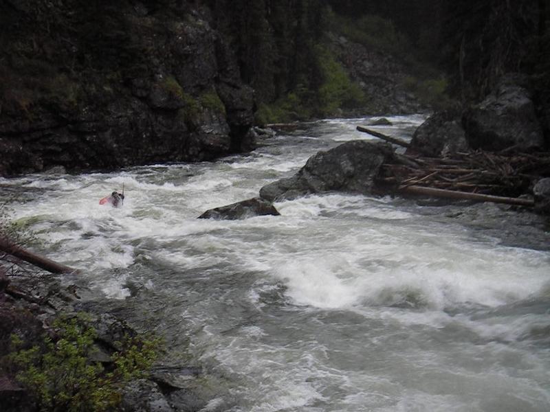
Colt Killed Creek is a 12 mile run through a pristine, roadless canyon.
Go prepared for a full day on the river in a remote, wilderness setting.
From the put in to Storm Creek Pack Bridge expect continuous class
IV whitewater. From Storm Creek down things start to ease
up, with the last few miles being a class II swiftwater cruise. Wood can
bee a serious hazard on this run so don't run any drops blind. As
noted in the flows section, the run increases in difficulty as flow increases.
The Colt Killed creek has an interesting history. It was named by the
Lewis and Clark expedition in September of 1805. Exhausted, starving and
finding no game, the party butchered a horse to eat, and named the creek
Colt Killed Creek. In 1907 the creek was given the name White Sand on the
General Land Office map. In 1988 regional historian Lalia Boone
successfully lobbied to have the name changed back to Colt Killed
Creek, though it took many years for maps to be updated (Titone). Some
guide books, and many boaters and locals still call it White Sand.
"Here we wer compelled to kill a colt for our men & Selves to eat for a want of
meat & we named the South fork Colt Killed Creek and this river we call
Flathead River (Lochsa). The mountains which we passed to day much worst than
yesterday the last excessively bad & thickly strowed with falling
timber & Pine Spruc fur hackmatak & Tamerack, steep & stoney our men
and horses much fatigued." - Meriwether Lewis. September 14, 1805
There is additional whitewater upstream from the put in on upper Colt
Killed Creek (Class V), and Big Sand Creek (class V), a tributary of
upper Colt Killed. For more information on these runs, see links to
American Whitewater in the Planning Tools section.
Logistics:
Exit Hiway 12 at Lochsa Lodge / Powell Ranger Station, and take FS
road 102 for 2.2 miles to the bridge at the confluence of Colt Killed
Creek and the Crooked Fork. This is the take out, and
the source of the Lochsa River.
To get to the put in, cross the bridge and continue 4.2 miles up
FS road 111 to FS road 360. Continue on FS 360 for 5.9 miles to
FS road 359. Continue down 359 for 5.6 miles until you reach the
river. Note that road 360 crosses Savage Pass which is
6,168' in elevation, and is usually snowed in till late June.
Camping is available near the take out at White Sand Campground (3,560'),
and at Powell, which is a short distance downstream. A further
3 miles downstream on the Lochsa are Whitehouse and Wendover Campgrounds.
There is also developed camping up FS road 360, a short distance past the
359 junction, at Colt Creek Campground (5,700').
Recommended Reading:
Ambrose, Stephen.
Undaunted Courage:Meriwether Lewis, Thomas Jefferson, and the Opening of the American West. Simon & Schuster, 1997.
Egan, Timothy.
The Big Burn:Teddy Roosevelt and the Fire that Saved America. Haughton Milflin Harcourt, 2009.
Moore, Bud.
The Lochsa Story:Land Ethics in the Bitterroot Mountains. Mountain Press Publishing Company, 1996.
Titone, Julie.
Small River To Be Known As Colt Killed Creek. Spokesman Review [Spokane] 8 May 1995, Online ed., NATION/WORLD sec.
Season and Flow Information:
The season starts when the road to the put in is clear of snow. This can vary widely, but it generally doesn't happen until late June, when Savage Pass (6,160') and all the shady corners finally melt. Stories abound of boaters getting skunked trying to get into Colt Killed. The neareast online gage is on the Lochsa near Lowell. When the Lochsa is above 4,000 cfs, Colt Killed jumps up a notch in difficulty. Minimum level is around 2,500 cfs. While there is no official correlation, 4,000 cfs on the Lochsa equates to roughly 1,200 cfs on Colt Killed. This is just a rough, eye ball estimate.
Stream Stats:
|
Average Gradient: |
70 fpm |
|
Maximum Gradient: |
N/A fpm |
|
Difficulty: |
Class III/IV |
|
Season: |
Late June |
|
Minimum Level: |
2,500@Lochsa |
|
Maximum Level: |
N/A |
|
Quality Rating: |
Eye Candy |